
How to Reach Kedarnath in 2026: Route, Registration, Transport, Stays and a 4-Day Itinerary
Learn how to reach Kedarnath in 2026 by road, trek or helicopter, with official registration steps, stay choices, a realistic 4-day itinerary and safety checks.
What you will discover
- Kedarnath has no road or railway station at the temple: most journeys combine a road trip to Sonprayag, a regulated local transfer to Gaurikund and a roughly 16 km mountain trail.
- Char Dham registration is compulsory; use the Uttarakhand government portal, add every pilgrim, download the QR-coded letter and carry valid photo identification.
- A four-day Haridwar itinerary is safer and more humane than forcing the road journey, climb, darshan and descent into an unrealistic schedule.
- Official helicopter seats are linked only through IRCTC HeliYatra, and every air itinerary needs a weather-cancellation backup.
- Guptkashi, Sitapur or Sonprayag work as approach bases; a night at Kedarnath is useful when health, weather and confirmed accommodation allow it.
The road north from Rishikesh does not reveal Kedarnath at once. It follows river bends through Devprayag and Rudraprayag, climbs the Mandakini valley, and finally deposits the traveller at a chain of handoffs: vehicle to shuttle, shuttle to trail, certainty to weather. Only after that does the temple appear—grey stone held beneath a vast white amphitheatre.
That layered approach is why ‘How do I reach Kedarnath?’ cannot be answered with one train number or one taxi fare. Kedarnath is a pilgrimage town at about 3,584 metres, and the official temple committee describes it as a 16 km trek from Gaurikund. Every sensible plan must connect the plains, the mountain road, registration, the final climb and a safe return.
This guide does exactly that for the 2026 season. It uses official Uttarakhand registration, tourism and temple-committee information for requirements and fixed channels; it labels road times as planning estimates; and it gives you a four-day itinerary with room for the Himalaya to remain the Himalaya.
How to reach Kedarnath: the direct answer
Travel first to Haridwar, Rishikesh or Dehradun. Continue by road through Devprayag, Srinagar, Rudraprayag and Guptkashi toward Sonprayag. Private through-traffic normally stops at Sonprayag; follow the current authorised local-transfer arrangement to Gaurikund. From Gaurikund, reach Kedarnath by the mountain trail—official BKTC information describes it as 16 km—or use a properly booked pony, palanquin or helicopter option subject to current rules, health and weather.
There is no direct train, bus or private car to the temple door. Helicopters also do not depart from Haridwar: pilgrims travel by road to an operating helipad in the Kedarnath valley and fly the short final sector. The Uttarakhand portal says Yatra registration is compulsory and links helicopter booking only to IRCTC HeliYatra.
Kedarnath journey quick facts for 2026
| Planning question | Careful answer |
|---|---|
| Where does the motorable approach end? | Plan around Sonprayag for parking/traffic control and Gaurikund as the traditional trailhead; follow that day’s authorised transfer arrangement. |
| How long is the final trail? | BKTC states 16 km from Gaurikund. Some older tourism pages still show 14 km, so plan conservatively for the longer current route and local diversions. |
| Is registration compulsory? | Yes. The official portal requires pilgrim and vehicle registration as applicable, a QR-coded Yatra Registration Letter and verification. |
| Nearest airport | Jolly Grant Airport near Dehradun; the remaining journey is by mountain road and then trail or helicopter. |
| Nearest useful rail gateways | Rishikesh is listed by official sources as the nearest station; Haridwar generally offers broader rail connectivity. Compare the actual train and arrival time you can secure. |
| Best minimum duration from Haridwar | Three days is an aggressive minimum; four days gives a more responsible approach, temple night or buffer, descent and return. |
| Can weather change the plan? | Yes. Road controls, rain, landslides, visibility, cold and helicopter cancellations can change access. Recheck immediately before and during travel. |
| Is a ropeway operating now? | Do not plan your present journey around a proposed future ropeway. Use only transport that official authorities confirm as operational for your dates. |
The Kedarnath route, step by step
The most common approach begins at Haridwar or Rishikesh. Distances quoted online vary because map endpoints differ—some stop at Guptkashi or Sonprayag, some at Gaurikund, and some add the walking trail. Road works, traffic holds and mountain conditions also make arrival time more important than a neat kilometre total.
| Stage | What happens | Planning note |
|---|---|---|
| Haridwar / Rishikesh → Devprayag | The road enters the Garhwal hills and follows the river toward the confluence of Bhagirathi and Alaknanda. | Start in daylight. Do not use a plains-road speed estimate for the mountains. |
| Devprayag → Srinagar → Rudraprayag | The route continues through major service towns and reaches the confluence of Alaknanda and Mandakini at Rudraprayag. | Useful zone for fuel, food and a contingency halt. |
| Rudraprayag → Agastyamuni → Guptkashi | The journey turns into the Mandakini valley and gains elevation. | Guptkashi is a practical overnight base with more stay options than the upper road. |
| Guptkashi → Sitapur → Sonprayag | Traffic and pilgrim checks become more concentrated near the final road approach. | Allow queue time and obey current parking and vehicle controls. |
| Sonprayag → Gaurikund | Pilgrims use the authorised local transfer operating for the season/day. | Do not promise yourself a fixed transfer time during peak crowd or weather controls. |
| Gaurikund → Kedarnath | A high-altitude ascent on foot or by regulated pilgrimage support; helicopter travellers use a separate helipad plan. | Begin only when health, daylight, weather and official instructions support it. |
The drive itself belongs to the pilgrimage. At Devprayag, two rivers become the Ganga by name; at Rudraprayag, the Mandakini joins the Alaknanda. You do not need to turn these confluences into rushed sightseeing stops. Even a quiet pause, without delaying the mountain schedule, can place the road inside the sacred geography you are entering.
Kedarnath registration in 2026: the official process
Use registrationandtouristcare.uk.gov.in, the Uttarakhand Tourism Development Board’s official portal. Its current process is simple in outline: register or log in, create a tour with dates and chosen Dhams, add each pilgrim’s details, and download the Yatra Registration Letter. The portal describes the letter as QR-coded and requires verification at the destination.
- Create one account on the official portal; avoid lookalike domains and sponsored links.
- Create the tour with realistic start, end and Kedarnath visit dates. Do not select an aspirational date that ignores your road and acclimatisation plan.
- Add every traveller exactly as shown on valid identification. Check names, age, mobile number and selected Dham before submission.
- Download the Yatra Registration Letter and keep both an offline digital copy and a printed copy if practical.
- Register the vehicle where applicable and keep its documents accessible.
- Carry valid personal photo ID, prescribed medicines and the registration certificate to the verification point.
- Collect or follow the current Dham darshan slot-token process described by the official portal and local authorities.
The official portal lists physical registration and check points, including Sonprayag and Kedarnath, but online completion before departure reduces uncertainty. Registration is free according to the portal’s explanation of the safety and monitoring exercise. If an agent demands a mysterious ‘government registration package’, compare it with the official process before paying.
Bus, shared vehicle, taxi or self-drive: which approach fits you?
A bus can be economical, but seasonal departures and hill-road stops make exact arrival times uncertain. Ask the authorised station counter whether the service terminates at Guptkashi, Sonprayag or another point and how the onward connection works. Avoid building a same-day trek around a bus that reaches the upper valley late.
A private taxi gives families more control over breaks and luggage. Choose a driver experienced on Uttarakhand mountain roads, clarify whether parking, waiting days and driver accommodation are included, and obtain the vehicle details. A low headline quote can grow through undefined waiting charges; a written itinerary is more useful than bargaining over a single number.
Self-driving offers independence but also concentrates fatigue. The driver must handle long bends, rain, falling rocks, traffic holds and limited night visibility after an early start from the plains. Confirm current parking rules before departure and never assume a private vehicle will be allowed to continue from Sonprayag to Gaurikund.
| Mode | Works best for | Main limitation |
|---|---|---|
| Seasonal bus | Budget travellers who can tolerate connections and flexible arrival | Longer, variable journey; onward connection may still be required |
| Shared vehicle | Solo travellers on established local sectors | Departure and luggage depend on filling and local operations |
| Private taxi | Families, seniors and groups needing planned breaks | Higher cost; terms, driver experience and waiting charges need verification |
| Self-drive | Confident hill drivers with a rested second driver and flexible plan | Fatigue, parking controls and weather make it unsuitable for an overpacked schedule |
Gaurikund to Kedarnath: planning the final ascent
Treat the 16 km description as distance, not difficulty. The trail rises from the Gaurikund area to a settlement above 3,500 metres. Walking time varies enormously with fitness, crowd flow, rain, rest, load and response to altitude. Commercial pages that promise five hours may describe a fit traveller in favourable conditions; they should not become a family deadline.
Begin early enough to preserve daylight, but not before authorised movement and local conditions allow. Carry only what you can safely manage. Small rests taken before exhaustion are better than a long collapse after it. Drink regularly without forcing excessive water, eat familiar food and protect yourself from both sun and sudden rain.
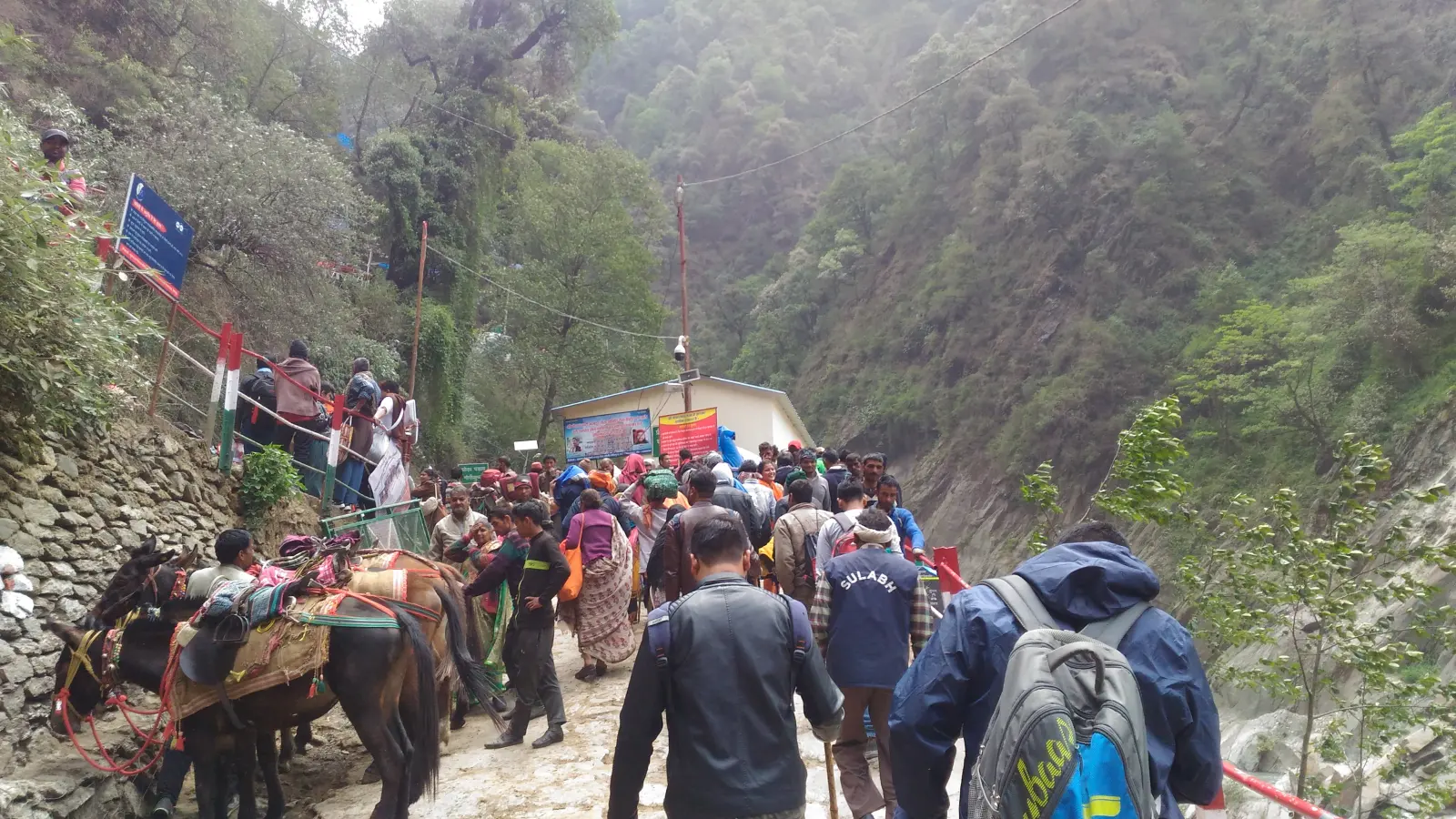
Real photographPony, mule and palanquin services should be arranged only through the authorised system operating locally. Confirm the official rate display, receipt, pickup point and whether the quoted amount covers one direction. Animal welfare matters: do not overload, demand unsafe speed or obstruct handlers. A support service reduces walking load but does not remove cold, altitude or weather exposure.
If you develop severe breathlessness at rest, confusion, faintness, loss of coordination, chest pain or rapidly worsening illness, do not interpret it as spiritual purification. Seek medical help and descend when professionals advise. The pilgrimage does not ask a family to ignore a medical emergency.
How to reach Kedarnath by helicopter—without falling for a fake ticket
The Uttarakhand registration portal states that heli services can be booked only through IRCTC and links directly to HeliYatra. Complete Yatra registration first, then follow the current IRCTC eligibility, identity, baggage, reporting and cancellation rules. Do not pay a person who claims to create a confirmed government seat through WhatsApp.
The exact operating helipads, schedules and fares are season-specific. Commercial guides commonly mention Guptkashi, Phata and Sersi, but only the live official booking interface should decide what is actually available for your date. Match every passenger’s booking data to valid ID and read the operator instructions before travelling to the helipad.
A helicopter is not a weather-proof appointment. Himalayan visibility and wind can delay or cancel flying. Keep a buffer day, a night-stay plan and enough flexibility to accept that darshan may move. Do not book a nonrefundable onward train or flight so tightly that one cancelled sector turns safety into pressure.
Where to stay for Kedarnath: choose the base that solves your next morning
Guptkashi offers a broad approach base and is useful when the group reaches the valley late or wants distance from Sonprayag congestion. Sitapur and Sonprayag place you closer to the final transfer but may have heavier seasonal demand. BKTC’s official Kedarnath information mentions nearby accommodation at Sitapur and BKTC guest houses at Sonprayag and Guptkashi; verify live availability rather than assuming a room exists.
Staying at Kedarnath allows an evening or morning atmosphere without forcing immediate descent, but accommodation is simpler, colder and limited. Reserve through a traceable property or an official provider such as GMVN where available. Confirm the exact property location, cancellation terms, bedding and check-in procedure. A room described as ‘Kedarnath’ may be in the wider route region rather than beside the temple.
| Base | Why choose it | What to watch |
|---|---|---|
| Guptkashi | More services and a sensible break after the long drive | Requires an earlier road start toward Sonprayag |
| Sitapur | Closer approach without relying on the most congested endpoint | Seasonal availability and local transfer still need confirmation |
| Sonprayag | Closest common road-control base for the Gaurikund transfer | Parking, queues and room demand can be intense |
| Kedarnath | Supports evening/morning worship and avoids a same-day round trip | High altitude, cold, basic facilities and limited inventory |
A realistic 4-day Kedarnath itinerary from Haridwar
This itinerary is intentionally not a race. It assumes road-and-trek travel, a temple night and average uncertainty. Add another buffer day for seniors, children, monsoon travel, a helicopter-dependent plan or any group whose health requires a gentler pace.
| Day | Plan | Why it works |
|---|---|---|
| Day 1 | Leave Haridwar or Rishikesh early; travel through Devprayag and Rudraprayag; stay in Guptkashi, Sitapur or a confirmed upper-valley base. | Separates the long mountain drive from the climb and gives the driver and pilgrims proper rest. |
| Day 2 | Proceed through Sonprayag under current controls, transfer to Gaurikund, begin the ascent early, check into confirmed Kedarnath accommodation and follow day-of darshan instructions. | Protects daylight and avoids promising a rushed descent after a demanding climb. |
| Day 3 | If health and access allow, complete morning worship; descend to Gaurikund; transfer to the road base; stay in Guptkashi or Rudraprayag. | The downhill is still strenuous. A mountain night prevents an exhausted late drive to the plains. |
| Day 4 | Return through Rudraprayag and Devprayag to Rishikesh/Haridwar with time for traffic delays. | Creates a clean travel day and reduces the risk of missing an immediate onward connection. |
For a helicopter itinerary, replace the trail day with the official reporting and flight plan but keep the buffer. If the flight is cancelled, decide in advance whether your group can safely switch to the trail, wait for the permitted alternative or return. Never let sunk cost make that health decision for you.
Health, monsoon and road updates: the plan must stay alive
Kedarnath’s altitude is not a decorative statistic. Cold, exertion and lower oxygen can expose problems that are invisible at home. Travellers with heart, lung, mobility or other medical concerns should seek individual medical advice before departure. Carry prescribed medicines in person, not buried in shared luggage.
July and August can bring heavy rain, landslides and route controls. A published annual opening season is not a promise that every road or trail will remain accessible every hour. Check official Uttarakhand weather, district and Yatra updates immediately before the mountain drive and again at your overnight base. Follow closures even when accommodation and transport have already been paid.
- Keep one buffer day between the planned return and an important flight, exam, ceremony or medical appointment.
- Do not begin the upper road or trek because another group is continuing; evaluate your own health and the official instruction.
- Carry offline copies of registration, IDs, booking confirmations, insurance details and emergency contacts.
- Tell one person at home the route, accommodation names and expected check-in times.
- If travelling in monsoon, assume that a clear morning forecast can still change and pack for rain without making the bag dangerously heavy.
- Purchase travel services with written cancellation terms; weather disruption is common enough to discuss before payment.
The document and packing system that prevents small failures
Use two slim waterproof pouches. The first stays with one responsible adult and holds IDs, QR registration letters, cash, essential receipts and medicines. The second stays with another adult and contains duplicates and emergency contacts. Each pilgrim should still carry personal identification as required.
Wear layers: a moisture-managing inner layer, warm mid-layer and rain/wind shell are more adaptable than one bulky garment. Add gloves, warm head covering, suitable socks and already-tested footwear. A light walking pole can improve stability, but new shoes and an overloaded backpack can turn the route into injury.
| Keep accessible | Pack thoughtfully | Leave behind |
|---|---|---|
| QR letter, ID, medicines, water, phone/power bank, small cash | Warm layers, rain shell, gloves, sun protection, simple food, tested footwear | Hard suitcases on the trail, unnecessary valuables, untested gear, disposable clutter |
| Accommodation and transport details offline | Personal health note and emergency contact | Documents stored only in one phone or cloud account |
Twelve Kedarnath planning mistakes to avoid
- Believing a road reaches Kedarnath Temple and booking a taxi as though it does.
- Comparing distance figures without checking whether they end at Guptkashi, Sonprayag, Gaurikund or the temple.
- Skipping official Yatra registration or entering pilgrim details that do not match identification.
- Starting the long mountain drive after a sleepless overnight train and asking the driver to hurry.
- Planning the road journey and full ascent on the same day without a realistic daylight and fitness assessment.
- Assuming the Sonprayag–Gaurikund transfer will have no queue in peak season.
- Treating a fast trek time from a commercial page as a family deadline.
- Buying helicopter tickets from an unofficial agent or failing to keep a cancellation buffer.
- Booking an unverified ‘Kedarnath hotel’ without confirming its actual location.
- Carrying all IDs, medicines and confirmations in one bag or phone.
- Ignoring worsening altitude symptoms because the temple feels close.
- Booking a tight onward connection that encourages unsafe travel when weather changes.
Mandir Vedas is an independent devotional service through which families may submit names and gotra details for a Kedarnath Archana and receive temple-premises video proof. It is not the Shri Badarinath Kedarnath Temple Committee, Uttarakhand Tourism, IRCTC or the temple administration. Travel, registration, darshan, official pujas and helicopter bookings must be verified through their respective authorised channels.
A good route plan does not diminish faith by accounting for shuttle queues, medicines and rain. It makes room for faith by removing avoidable panic. When the documents are correct, the halt is sensible and the return is not being chased, the mind can finally stop calculating.
The final kilometres will still ask something of you. Walk them slowly enough to notice the Mandakini valley; travel them humbly enough to turn back if safety requires it. Kedarnath is not made sacred by defeating the mountain. The pilgrimage begins when we learn how to approach without pretending the mountain belongs to our schedule.
Frequently asked questions
What is the easiest way to reach Kedarnath?+
There is no single easiest option for everyone. Most pilgrims travel by road to the Sonprayag/Gaurikund approach and then use the 16 km trail. A properly booked helicopter can reduce walking, but it still requires road travel to the operating helipad and is subject to weather.
Can I reach Kedarnath Temple directly by car?+
No. A private car does not reach the temple. Plan for road controls around Sonprayag, the authorised local transfer to Gaurikund and the mountain trail, or use an official helicopter itinerary from an operating valley helipad.
How far is Kedarnath from Haridwar?+
Online totals vary because endpoints differ. The road journey runs from Haridwar through Rishikesh, Devprayag, Rudraprayag and Guptkashi toward Sonprayag/Gaurikund, followed by the roughly 16 km trail. Use a live map for your exact overnight base and allow a full mountain-road day.
Is Kedarnath registration compulsory in 2026?+
Yes. Tourist Care Uttarakhand says pilgrims and vehicles as applicable must be registered. Create the tour, add every pilgrim, download the QR-coded Yatra Registration Letter and carry it with valid ID for verification.
What is the official website for Kedarnath helicopter booking?+
Use the IRCTC HeliYatra website at heliyatra.irctc.co.in, preferably reached through the official Uttarakhand Tourist Care portal. The government portal states that heli services can be booked only through IRCTC.
How many days are enough for Kedarnath from Haridwar?+
Three days is an aggressive minimum. Four days is more realistic for a road-and-trek journey: approach and overnight, ascent and Kedarnath stay, descent and valley stay, then return. Add a buffer for weather, seniors or helicopter dependence.
Should I stay in Guptkashi, Sonprayag or Kedarnath?+
Guptkashi is a comfortable approach base, Sonprayag is closer to the final road transfer, and Kedarnath supports evening or morning worship without same-day descent. The right choice depends on arrival time, health and confirmed accommodation—not only distance.
Can senior citizens travel to Kedarnath?+
Many do, but suitability is individual. High altitude, cold, exertion and waiting can be serious. Seek medical advice for relevant conditions, use only authorised support, build extra time and be willing to stop or descend if symptoms appear.
Is the Kedarnath trek 14 km or 16 km?+
Some older official tourism content still mentions 14 km, while current BKTC information describes a 16 km trek from Gaurikund. Routes and measurements can differ, so plan conservatively for at least the longer figure and follow current local signage.
Can I visit Kedarnath during monsoon?+
The shrine season includes monsoon months, but heavy rain, landslides and road or trail controls can interrupt travel. Do not rely on a seasonal opening date alone. Check official weather and route updates immediately before and during the journey and keep buffer days.
Sources and further reading
Travel requirements and temple schedules can change. These official sources were checked while preparing this guide.
- Tourist Care Uttarakhand — official Char Dham registration process, verification, health and helicopter links
- Uttarakhand Tourism — official Kedarnath destination and access overview
- Shri Badarinath Kedarnath Temple Committee — official Kedarnath overview, route facts and accommodation references
- IRCTC HeliYatra — official helicopter booking channel linked by Uttarakhand Tourism
- GMVN — official Uttarakhand government accommodation booking portal
- India Meteorological Department — official weather information
- Wikimedia Commons — Gaurikund–Kedarnath trail photograph by Prateek as a traveller